Monday, September 20, 2010

Culverts 1: A case of the F***its

I'm planning a series on culvert whoopsies that I find along my journeys around the desert southwest. Culverts are a necessity for roads and other short crossings. It is also important that culverts be appropriately sized and placed within/on the substrate. Culverts can also have incredibly damaging consequences on the aquatic environment if improperly sized/placed. Even bad culverts in ephemeral streams can have downstream consequences (via excess sedimentation from erosion, for example). I come across a lot of bad (and some good) examples in my travels and am happy to share them for discussion.

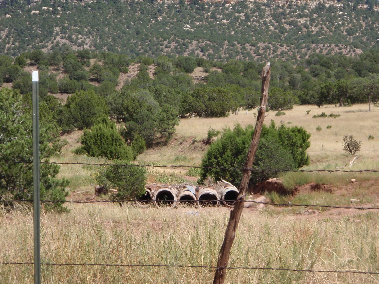
This is a set of culverts on an small, ephemeral arroyo near Apache Springs, NM. Normally, these small (-ish) arroyos only run in response to heavy rain events and when they do flow, they often flow very big. They are characterized by either upland or no vegetation, and in this neck of the woods, are easily erodible.

The landowner, at some time in the past, installed the series of five culverts in an attempt to provide a crossing that would work during inclement weather. You can also see that the culverts have no road base or other roadway material on top of them. It's been eroded over time to the point of being non-functional. If you look to the right of the photo, you can sort of see the ad-hoc at-grade crossing that the landowner has used to bypass the failed culverts. When we drove by, I had my colleague stop and back up so he could see it, as well. We both laughed and said this landowner had a case of the "aww, f***its" with respect to the culvert. It's a pretty common sight, here in the low-income, rural southwest.

Saturday, September 18, 2010

Saturday Site Visits, Folsom Falls on the Dry Cimarron

In June, I had the opportunity to look at a restoration project on the Dry Cimarron River, near Folsom, NM. On the way back, we stop for a quick look at Folsom Falls. I wished I had the chance to stay longer and really hike around the fall for better vantage points, but we had a long drive back to our respective starting points.

Folsom Falls is formed by the Dry Cimarron River flowing over a lip of what Baldwin and Muehlenberger identified as the Baby Capulin basalt of the Raton-Clayton volcanic field (RCVF). The RCVF comprises mostly basaltic to nepheletic cinder cones, andesitic to dacitic necks and domes, and a very cute shield volcano named Sierra Grande (Baldridge, 2004). The RCVF is Pliocene-Quaternary in age, with volcanism commencing around 7.2 Ma and ending with the Capulin eruption around 60ka. RCVF is approximately contemporaneous with the Ocate Volcanic field, about 50+ miles to the west and is on the Jemez lineament, a zone of volcanism extending from the Springer volcanic field in east-central AZ to the RCVF. The Jemez lineament cuts across tectonic provinces, and as such, its origin is not well understood (Baldridge, 2004).

The view above looks south across the falls. The view to the left is looking downstream. The riparian habitat is well-developed, suggesting the surrounding ranchers aren't letting their cows in to graze (yay!). However, the local kids apparently use it as their party spot, judging from the amount of broken glass and other anthropogenic detritus.

I like the area, because it is very reminiscent of my home country in eastern WA, with lots of basalt, grasslands and the occasional hidden ponderosa stand, much like the landscape near Spokane, WA. There's a Spanish word, querencia, for a place from which one draws strength, which tugs at one's heartstrings. This area of New Mexico is definitely one of mine.

Google Earth image of the location.


Baldwin and Meuhlenberger sketch of Folsom Falls stratigraphy.


Link: http://vulcan.wr.usgs.gov/Volcanoes/NewMexico/Capulin/VisitVolcano/framework.html

References:

Baldridge, W. Scott, Pliocene-Quaternary Volcanism in New Mexico and a model for genesis of magmas in continental extension, in, The Geology of New Mexico, a Geologic History, NMGS, 2004

Baldwin, Brewster and Muehlenberger, William R., Geologic Studies of Union County, New Mexico, Bulletin 63, NMBMMR, 1959

Sunday, June 20, 2010

Park Meme

Okay, so I'm slow on the uptake. Here's mine:

Most visited:
10: Glacier
9: Acadia
8: Grand Teton
7: Cuyahoga Valley
6: Rocky Mountain
5: Olympic
4: Yellowstone
3: Yosemite
2: Grand Canyon
1: Great Smoky Mountains

Least Visited:
10: City of Rocks NR, Idaho
9: Cumberland Island NS, Georgia
8: Florissant Fossil Beds, Colorado
7: Chiricahua NM, Arizona
6: Tonto NM, Arizona
5: Dry Tortugas NP, Florida
4: Katmai NP & Preserve, Alaska
3: Kalaupapa NHP, Hawaii
2: Hagerman Fossil Beds NM, Idaho
1: Russel Cave NM, Alabama

Wednesday, June 16, 2010

Evidence of change - Relict channels and wetland soils in the Dry Cim and Gold Creek, NM

In the last couple of weeks, I've been able to see some relict fluvial features that are indicative of a former landscape condition. Sometimes there is enough local history/knowledge to get a very good idea of when major landscape change occurred (as in the case of the Dry Cimarron), in others you can make inferences from historical activity, but it's difficult to derive specific dates of change.

In both these cases, the specific change has been incision due to anthropogenic changes to the landscape combined with flood/erosion events. The Dry Cim has been heavily grazed in the past, and had specific flood events that caused channel avulsion/incision to bedrock in the location where my photos were taken.

This photo shows the relict channel, with fine-grained sediment accumulation. One might think that it is a far-in-the-past feature, until you start talking to the landowner and/or folks who know the local hydrograph. Though one would need to age-date material in the relict channel to get an actual date range of the channel deposits, it's quite possible that it may be quite young. There was a ripper flood in 1910 or so, and the rancher indicated that floods in the 40s and 50s caused an extensive amount of incision - maybe 15-20 feet or more (down to bedrock in this location). So, much of the landscape change isn't actually in the far distant past.

The wider view of the above. It is interesting to note that the sediment in the relict channel is mostly clay-to-sand. Just below the relict channel in this photo is a large gravel bar deposited last year, mostly cobble-sized grains. I saw nothing that size in the relict channel.

The rancher here has reduced his herd from about 1200 to 500 head, and has mostly rested this reach for the past 4 years. The resulting riparian and fluvial changes from the release of grazing pressure have been phenomenal. He has beaver dams/ponds and a well-wetted, vegetated channel bottom, increasing bank storage and aquifer recharge. It's unlikely that the system will aggrade back to its original, pre-grazing, agriculture and logging elevation, but it is in much better condition than I had hoped before I went out there. It helped to have a very wet winter for this region.

We also talked a lot about wetlands, and what anoxic environments are and the soil columns/profiles that occur in these environments. It just so happened that there was a big grey blob of soil on the opposite slope/bank of the relict channel. It was a splendid opportunity to discuss hydric soil indicators such as gleyed soils and oxidized root channels, even if relict. In this photo, you can see the oxidized root channels that occur when roots of hydrophytic plants carry oxygen down into the reduced environment. Rust then occurs along the root channels. In this instance, they are pervasive through the entire exposure. This blob of former wetland is also about 15 feet up from the stream bottom. Again, little grain size larger than sand. There was also a lens of shells near the bottom, and frequent scatterings of charcoal throughout, indicated upstream or adjacent fires. The three of us there that day loved the fact that even without a lab, a handlens, or a rock hammer, we could infer such a great deal about the landscape.

Speaking of relict wetlands, at Gold Creek in Valle Vidal, I got this great bank shot that's actually about 8 feet tall from stream bed to top-of-bank. Below the most recent soil column at the top, you can see a well-reduced horizon. Though I wasn't able to get a good close-up, it too has relict oxidized root channels and other hydric soil features.

Gold Creek had intensive logging in the past, as well as intensive grazing pressure prior to its acquisition by the USFS (it's still grazed, but I don't think as heavily). Looking at the surrounding landscape, we all surmised (me, especially) that it was likely that this drainage and others like it likely had fens at the extreme headwaters, that have now been incised and drained due to the landscape changes. This creek is now incised about 10-12 feet, but the channel bottom seems to be recovering to the point that it is forming an E-type channel. [We kind of puzzled about the gradient, though. Seemed too steep for an E, but my thought is that the source material grain size is too small to support any kind of a step-pool environment that the gradient would suggest. Crappy weathering volcanics, I think.]
Looking downstream towards Comanche Creek. There's probably about 200 or so feet of drop between the photo point and the confluence with Comanche Creek.

I'm amazed everytime I venture into the field about how much of an impact we have had on our environment, even on a little stream up at 9500 feet. I'm also amazed at, and thoroughly appreciate the dedication of the people I work with to restore these landscapes, from the rancher on the Dry Cim, to the folks working here. I may get frustrated on a day-to-day basis, but this, and they make it all worthwhile.
Sunday, June 13, 2010

What's Blooming in the Yard?

I have a lot of wildflowers coming up in the garden. It's hard not to spend at least a few minutes during the day wandering around to see what's up. There are also a bunch of other flowers in the neighborhood that are blooming, but not in my yard. Another post (to include some of the penstemons I've been itching to see on the Mesa).

Oenothera (evening primrose) -

This one is smaller than the first evening primrose that blooms in the spring (that one, I think, is Oenothera caespitosa and seems to prefer disturbed or shaley slopes). This one is about 1.25-1.5 in diameter, and I haven't yet figured out any particular habitat for it. Or it's scientific name, for that matter. But I'm closing in on it.


Linum lewisii (blue flax) One of the books I have differentiates between a Euro import and a native, but I sure can't tell the difference.


Penstemon - I have several varieties that I've planted as well as the ones that come up naturally (or at least from a SF Gardens seed mix for the Sangres). There are about 15-20 of this particular species in full bloom around the yard.


Gaillardia?


Another penstemon - this one I planted. Rocky Mountain
penstemon, I believe.


Phlox.


This one didn't get planted, but it's a different penstemon than all the others in the yard. Found growing under a juniper. It must have been here a year or two, as it is a fairly big patch, but I didn't notice it last year.


Castilleja or Indian paintbrush.


Gaura (whirling butterflies), with a penstemon backdrop. This one is going crazy this year.

Friday, May 7, 2010

A day near Mt. Taylor

I got to spend a day this last week near Mt. Taylor, a composite volcano north of Grants, NM. It was active approximately 3.3 to 1.5 million years ago, and overlies Cretaceous Interior Seaway sediments. The OF-GM-186 for the area is unavailable from the New Mexico Bureau of Geology and Mineral Resources at this time, so its difficult for me to tell you which of the Cretaceous sediments are exposed in my photos, but I do assume they include the Mancos Shale in one of its forms.
Mt. Taylor is sacred to most of the Native American tribes and pueblos in the southwest and much of the surrounding mesa-tops and the mountain itself have recently been designated a traditional cultural property, requiring both tribal and State Historic Preservation Officer consultation for federalized projects.
This designation makes uranium exploration and development more complex on private, state and federal lands. The price of uranium has risen in the last few years, making extraction more economically feasible, but the cost of environmental evaluation, permitting, and consultation must be absorbed into development costs. Though exploration companies may balk at the process, it's the cost of doing business in the area.
As an aside, the uranium source is mostly in the Jurassic Morrison and Todilto formations (Grants Mineral Belt), which do not surface in the immediate area where I was (though there has been considerable exploration, mining and milling on the east side in the past).

Photo 1 is a dome/neck on the southeast side of Mt. Taylor, near Seboyeta.

Photo 2 is the scenic potty view through the junipers. Basalt-capped Chivato Mesa, with Cretaceous sediments below.


I don't have detailed geologic maps for the area (see above), but I'm presuming this is Pt. Lookout with Mancos below?

Looking south from atop the mesa.


Looking east, with the Sandias in the distance.

I used the below websites and the 1991 Field guide to geologic excursions in New Mexico and adjacent areas of Texas and Colorado (Bulletin 137, NMBMMR) as references.

http://geoinfo.nmt.edu/tour/landmarks/mt_taylor/home.html
http://en.wikipedia.org/wiki/Uranium_mining_in_New_Mexico

Wednesday, May 5, 2010

Palm Canyon, CA, June 2005

I don't have a lot of time, but want to post some pix from a hike up Palm Canyon a few years back. I haven't the resources to really say too much about the geology, either, as my references for the area are still packed away. This will have to do. Pictures courtesy of MK, 2005.

One of my favorite places in desert SoCal is Palm Canyon. I first went with the ex on a planning trip for a GSA field trip he was organizing for the Salton Trough and Sierra al Mayor in Baja, way back when. I loved it on that trip, and still do.

In 2005, I had some field work in Coachella Valley, on the Whitewater River. We all had some extra time, so we decided to hike up to Palm Canyon at the end of our work day. It's on the Agua Caliente Reservation, so you have to pay to enter the park, but it's well worth it. The first photo shows the view from the upper parking area northeast towards Palm Springs with the Little San Berdoos in the way background (the thin grey line on the horizon).

This is a waterfall in a side canyon to the main canyon. The stream has carved smooth notches into the boulders making up the canyon walls and floor. As we hiked out from this side canyon, we all felt an earthquake, one of about three that day, if I recollect correctly.
Though it was a pretty warm day out (as summer days in Coachella usually are), it was cool and misty in the side canyon.
The hike up the canyon is spectacular, both geologically and botanically. The palm oases were well-managed as a food, water, clothing, and shelter source for the Coachella Valley tribes (as well as AZ tribes with access to oases). Plant, bird, herp, and insect species pretty much abound. There are a few good references, but Jim Cornett from the Living Desert Museum in Palm Desert, has published quite extensively on the natural history of the Lower Coloradan desert.


Hiking down to the side canyon, just before the earthquake. Palm Canyon is also home to a primary fault in the Santa Rosa Mylonite zone, the Palm Canyon Fault. For about a couple miles or so, as you drive south from Palm Springs to Palm Desert, you can see the deformation of the granodiorite wane as you get closer to the edge of the deformation zone. The fault trends southwest-northeast, and the deformation (if I recollect correctly and please correct me if I misremember) is evident primarily on the southeast side or upper plate.

This side canyon is in the lower plate, and has relatively undeformed geology, as compared to the other side of the canyon.


This speaks for itself. This photo was taken on the main trail, fairly close to the fault. The granodiorites are well-sheared.


Yours truly, gesticulating madly at the surface expression of the Palm Canyon fault. It's pretty beat up, here.